
Thank you for supporting this site ❤️
Make a donation
Make a donation
Odenthal topographic map
Click on the map to display elevation.
Thank you for supporting this site ❤️
Make a donation
Make a donation
About this map
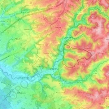
Name: Odenthal topographic map, elevation, terrain.
Average elevation: 143 m
Minimum elevation: 60 m
Maximum elevation: 237 m
Thank you for supporting this site ❤️
Make a donation
Make a donation
Other topographic maps
Click on a map to view its topography, its elevation and its terrain.
Bilstein
Alemania > Renania del Norte-Westfalia > Rheinisch-Bergischer Kreis > Kürten
Average elevation: 246 m