
Kamenz topographic map
Interactive map
Click on the map to display elevation.
About this map
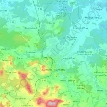
Name: Kamenz topographic map, elevation, terrain.
Location: Kamenz, Bautzen, Sachsen, Deutschland (51.23001 13.99381 51.34336 14.17437)
Average elevation: 186 m
Minimum elevation: 134 m
Maximum elevation: 382 m
Other topographic maps
Click on a map to view its topography, its elevation and its terrain.
Roter Berg
Deutschland > Sachsen > Kamenz
Roter Berg, Kamenz, Bautzen, Sachsen, 01917, Deutschland
Average elevation: 174 m