
Thank you for supporting this site ❤️
Make a donation
Make a donation
Bushmans River topographic map
Click on the map to display elevation.
Thank you for supporting this site ❤️
Make a donation
Make a donation
About this map
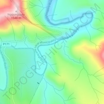
Name: Bushmans River topographic map, elevation, terrain.
Average elevation: 1,291 m
Minimum elevation: 1,183 m
Maximum elevation: 1,542 m
Thank you for supporting this site ❤️
Make a donation
Make a donation
Other topographic maps
Click on a map to view its topography, its elevation and its terrain.
Imbabazane Ward 2
South Africa > KwaZulu-Natal > Uthukela District Municipality > Imbabazane Local Municipality
Average elevation: 2,006 m
Loskop
South Africa > KwaZulu-Natal > Uthukela District Municipality > Imbabazane Local Municipality
Average elevation: 1,182 m