
Black Creek topographic map
Interactive map
Click on the map to display elevation.
About this map
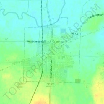
Name: Black Creek topographic map, elevation, terrain.
Location: Black Creek, Outagamie County, Wisconsin, United States (44.46580 -88.46111 44.48370 -88.44030)
Average elevation: 242 m
Minimum elevation: 232 m
Maximum elevation: 258 m
Other topographic maps
Click on a map to view its topography, its elevation and its terrain.
Duck Creek
United States > Wisconsin > Outagamie County
Duck Creek, Outagamie County, Wisconsin, 54155, United States
Average elevation: 226 m
Kimberly
United States > Wisconsin > Outagamie County
Kimberly, Outagamie County, Wisconsin, 54136, United States
Average elevation: 225 m
Kaukauna
United States > Wisconsin > Outagamie County
Kaukauna, Outagamie County, Wisconsin, 54130, United States
Average elevation: 216 m
Appleton
United States > Wisconsin > Outagamie County
Appleton, Outagamie County, Wisconsin, United States
Average elevation: 240 m