
Thank you for supporting this site ❤️
Make a donation
Make a donation
Grottoes topographic map
Click on the map to display elevation.
Thank you for supporting this site ❤️
Make a donation
Make a donation
About this map
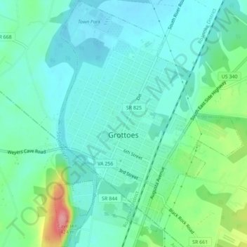
Name: Grottoes topographic map, elevation, terrain.
Location: Grottoes, Rockingham County, Virginia, United States (38.25208 -78.83775 38.28564 -78.80520)
Average elevation: 346 m
Minimum elevation: 322 m
Maximum elevation: 425 m
Thank you for supporting this site ❤️
Make a donation
Make a donation
Other topographic maps
Click on a map to view its topography, its elevation and its terrain.
Harrisonburg/Warm Springs Turnpike Park
United States > Virginia > Rockingham County > Bridgewater
Average elevation: 378 m
Thank you for supporting this site ❤️
Make a donation
Make a donation
Thank you for supporting this site ❤️
Make a donation
Make a donation
Thank you for supporting this site ❤️
Make a donation
Make a donation