
Thank you for supporting this site ❤️
Make a donation
Make a donation
Punta Morro topographic map
Click on the map to display elevation.
Thank you for supporting this site ❤️
Make a donation
Make a donation
About this map
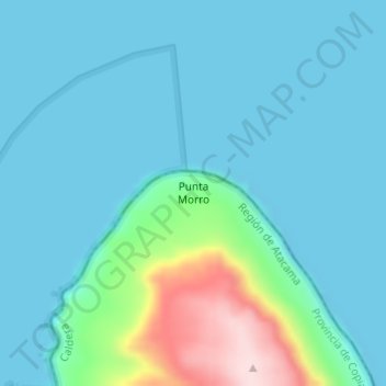
Name: Punta Morro topographic map, elevation, terrain.
Average elevation: 48 m
Minimum elevation: 0 m
Maximum elevation: 297 m
Thank you for supporting this site ❤️
Make a donation
Make a donation
Other topographic maps
Click on a map to view its topography, its elevation and its terrain.
Humedal Desembocadura del Río Copiapó
Chile > Atacama Region > Provincia de Copiapó > Caldera
Average elevation: 31 m
Bien Nacional Protegido Yacimiento Paleontológico Cerro Ballena
Chile > Atacama Region > Provincia de Copiapó > Caldera
Average elevation: 53 m