
Autonomous City of Buenos Aires topographic map
Interactive map
Click on the map to display elevation.
About this map
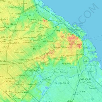
Name: Autonomous City of Buenos Aires topographic map, elevation, terrain.
Location: Autonomous City of Buenos Aires, Argentina (-34.70564 -58.53145 -34.52655 -58.33514)
Average elevation: 14 m
Minimum elevation: -3 m
Maximum elevation: 48 m
Other topographic maps
Click on a map to view its topography, its elevation and its terrain.