
Thank you for supporting this site ❤️
Make a donation
Make a donation
Mora topographic map
Click on the map to display elevation.
Thank you for supporting this site ❤️
Make a donation
Make a donation
About this map
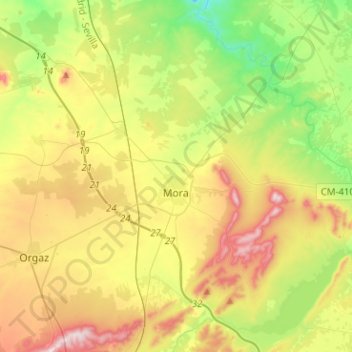
Name: Mora topographic map, elevation, terrain.
Location: Mora, Toledo, Castile-La Mancha, 45400, Spain (39.59519 -3.83718 39.78972 -3.65885)
Average elevation: 717 m
Minimum elevation: 546 m
Maximum elevation: 961 m
Thank you for supporting this site ❤️
Make a donation
Make a donation
Other topographic maps
Click on a map to view its topography, its elevation and its terrain.