
Somerset County topographic map
Interactive map
Click on the map to display elevation.
About this map
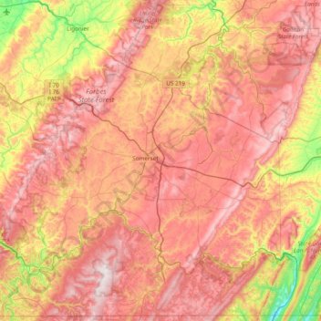
Name: Somerset County topographic map, elevation, terrain.
Location: Somerset County, Pennsylvania, United States of America (39.72137 -79.41778 40.28537 -78.65841)
Average elevation: 632 m
Minimum elevation: 221 m
Maximum elevation: 975 m
Somerset County along with Garrett County is one of the snowiest inhabited locations in the United States, with the highest elevations of the county averaging 150+ inches of snow each winter. The county's elevation and general proximity to both the Great Lakes and the Atlantic Ocean causes snow from both Nor'easters and lake effect upslope snow events to fall from late October through early April. Snow has been recorded in Somerset County in every month except July, although local lore has it that even July saw snow in 1816, "the year without a summer." Mount Davis, the highest natural point in the state of Pennsylvania at 3,213 feet (979 m), is located in the southern part of the County.
Other topographic maps
Click on a map to view its topography, its elevation and its terrain.
Lehigh County
United States of America > Pennsylvania
Lehigh County, Pennsylvania, United States of America
Average elevation: 186 m
Doylestown
United States of America > Pennsylvania > Doylestown
Doylestown, Bucks County, Pennsylvania, 18901, United States of America
Average elevation: 108 m
Haycock Township
United States of America > Pennsylvania > Haycock Township
Haycock Township, Bucks County, Pennsylvania, United States of America
Average elevation: 159 m
Beaver County
United States of America > Pennsylvania
Beaver County, Pennsylvania, United States of America
Average elevation: 325 m
Warren County
United States of America > Pennsylvania
Warren County, Pennsylvania, United States of America
Average elevation: 500 m
Erie County
United States of America > Pennsylvania
Erie County, Pennsylvania, United States of America
Average elevation: 272 m
Bethel Township
United States of America > Pennsylvania > Bethel Township
Bethel Township, Lebanon County, Pennsylvania, 17026, United States of America
Average elevation: 192 m
South Heidelberg Township
United States of America > Pennsylvania > South Heidelberg Township
South Heidelberg Township, Berks County, Pennsylvania, United States of America
Average elevation: 186 m
Starks
United States of America > Pennsylvania > Starks
Starks, Lackawanna County, Pennsylvania, 18641, United States of America
Average elevation: 228 m
Clover Hill
United States of America > Pennsylvania > West Pike Run Township > Clover Hill
Clover Hill, West Pike Run Township, Washington County, Pennsylvania, 15427, United States of America
Average elevation: 347 m
Bedford County
United States of America > Pennsylvania
Bedford County, Pennsylvania, United States of America
Average elevation: 491 m
Crawford County
United States of America > Pennsylvania
Crawford County, Pennsylvania, United States of America
Average elevation: 382 m
Richlandtown
United States of America > Pennsylvania > Richlandtown
Richlandtown, Bucks County, Pennsylvania, 18955, United States of America
Average elevation: 160 m
Columbia County
United States of America > Pennsylvania
Columbia County, Pennsylvania, United States of America
Average elevation: 306 m
South Mountain Park
United States of America > Pennsylvania > Lower Saucon Township > Star Village
South Mountain Park, Star Village, Lower Saucon Township, Northampton County, Pennsylvania, United States of America
Average elevation: 169 m
Altoona
United States of America > Pennsylvania > Altoona
Altoona, Blair County, Pennsylvania, United States of America
Average elevation: 443 m
Philadelphia County
United States of America > Pennsylvania
Philadelphia County, Pennsylvania, United States of America
Average elevation: 39 m
Delaware County
United States of America > Pennsylvania
Delaware County, Pennsylvania, United States of America
Average elevation: 76 m
Lycoming County
United States of America > Pennsylvania
Lycoming County, Pennsylvania, United States of America
Average elevation: 415 m
Wardville
United States of America > Pennsylvania > Wardville
Wardville, Perry County, Pennsylvania, 17062, United States of America
Average elevation: 206 m