
Navidad topographic map
Interactive map
Click on the map to display elevation.
About this map
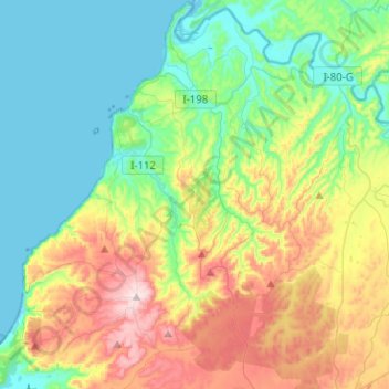
Name: Navidad topographic map, elevation, terrain.
Average elevation: 141 m
Minimum elevation: -1 m
Maximum elevation: 444 m
Other topographic maps
Click on a map to view its topography, its elevation and its terrain.
La Boca
Chile > O'Higgins Region > Provincia de Cardenal Caro
La Boca, Navidad, Provincia de Cardenal Caro, O'Higgins Region, Chile
Average elevation: 18 m
Pupuya
Chile > O'Higgins Region > Provincia de Cardenal Caro > Navidad
Pupuya, Navidad, Provincia de Cardenal Caro, O'Higgins Region, Chile
Average elevation: 120 m
Puertecillo
Chile > O'Higgins Region > Provincia de Cardenal Caro > Navidad > Puertecillo
Puertecillo, Navidad, Provincia de Cardenal Caro, O'Higgins Region, Chile
Average elevation: 109 m
Pichilemu
Chile > O'Higgins Region > Provincia de Cardenal Caro
Pichilemu, Provincia de Cardenal Caro, O'Higgins Region, Chile
Average elevation: 127 m