
Mioño topographic map
Interactive map
Click on the map to display elevation.
About this map
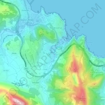
Name: Mioño topographic map, elevation, terrain.
Location: Mioño, Castro-Urdiales, Cantabria, 39709, España (43.33872 -3.22173 43.37872 -3.18173)
Average elevation: 88 m
Minimum elevation: -2 m
Maximum elevation: 437 m
La localidad se encuentra a 40 m de altitud sobre el nivel del mar, y a 5 km de la capital municipal, Castro Urdiales. Por la pedanía fluye y desemboca el río Cabrera, que nace en Otañes. Este pueblo tiene una playa, la de Dícido.
Other topographic maps
Click on a map to view its topography, its elevation and its terrain.
Cerredo
España > Cantabria > Castro-Urdiales
Cerredo, Castro-Urdiales, Cantabria, 39798, España
Average elevation: 356 m