
Pulau Tarakan topographic map
Interactive map
Click on the map to display elevation.
About this map
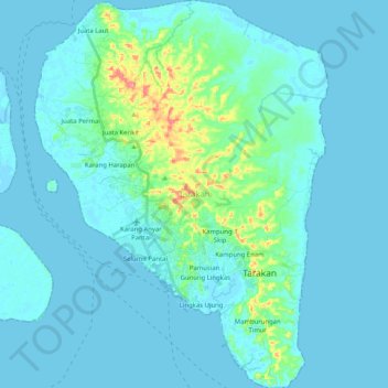
Name: Pulau Tarakan topographic map, elevation, terrain.
Location: Pulau Tarakan, Tarakan, Kalimantan Utara, 77112, Indonésie (3.23952 117.51449 3.44343 117.66909)
Average elevation: 11 m
Minimum elevation: -2 m
Maximum elevation: 102 m
Other topographic maps
Click on a map to view its topography, its elevation and its terrain.
Tarakan
Indonésie > Kalimantan Utara > Tarakan
Tarakan, Kalimantan Utara, 77112, Indonésie
Average elevation: 5 m