
56660 topographic map
Interactive map
Click on the map to display elevation.
About this map
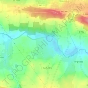
Name: 56660 topographic map, elevation, terrain.
Average elevation: 86 m
Minimum elevation: 47 m
Maximum elevation: 144 m
Other topographic maps
Click on a map to view its topography, its elevation and its terrain.
Rocnenet
France > Bretagne > Morbihan > Saint-Jean-Brévelay
Rocnenet, Saint-Jean-Brévelay, Pontivy, Morbihan, Bretagne, France métropolitaine, 56660, France
Average elevation: 84 m