
Make a donation
Mentougou District topographic map
Click on the map to display elevation.
Make a donation
About this map
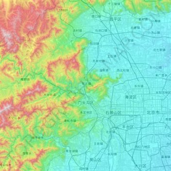
Name: Mentougou District topographic map, elevation, terrain.
Location: Mentougou District, Beijing, 102399, China (39.81052 115.41721 40.17749 116.16970)
Average elevation: 325 m
Minimum elevation: 27 m
Maximum elevation: 1,579 m
Make a donation
Other topographic maps
Click on a map to view its topography, its elevation and its terrain.
Beijing
Beijing is situated at the northern tip of the roughly triangular North China Plain, which opens to the south and east of the city. Mountains to the north, northwest and west shield the city and northern China's agricultural heartland from the encroaching desert steppes. The northwestern part of the…
Average elevation: 47 m
Make a donation