
Thank you for supporting this site ❤️
Make a donation
Make a donation
Puerto Cisnes topographic map
Click on the map to display elevation.
Thank you for supporting this site ❤️
Make a donation
Make a donation
About this map
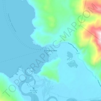
Name: Puerto Cisnes topographic map, elevation, terrain.
Average elevation: 168 m
Minimum elevation: -1 m
Maximum elevation: 1,345 m
Thank you for supporting this site ❤️
Make a donation
Make a donation
Other topographic maps
Click on a map to view its topography, its elevation and its terrain.
Isla Florencia
Chile > Aysen del General Carlos Ibanez del Campo Region > Provincia de Aysén > Cisnes
Average elevation: 13 m