
Lumpkin County topographic map
Interactive map
Click on the map to display elevation.
About this map
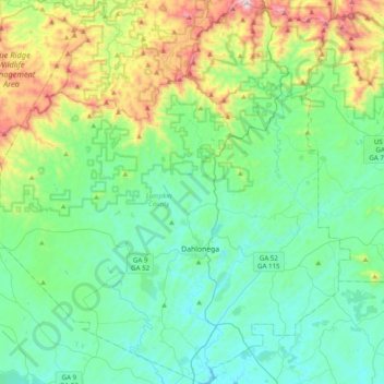
Name: Lumpkin County topographic map, elevation, terrain.
Location: Lumpkin County, Georgia, United States of America (34.41839 -84.19096 34.74110 -83.83153)
Average elevation: 554 m
Minimum elevation: 323 m
Maximum elevation: 1,330 m
Other topographic maps
Click on a map to view its topography, its elevation and its terrain.
Columbus
United States of America > Georgia > Columbus
Columbus, Muscogee County, Georgia, United States of America
Average elevation: 130 m
Vine City
United States of America > Georgia > Atlanta > Vine City
Vine City, Atlanta, Fulton County, Georgia, 30313, United States of America
Average elevation: 301 m