Geolocate

Daiyana topographic map

Interactive map

Click on the map to display elevation.

About this map

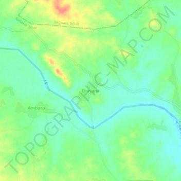
Name: Daiyana topographic map, elevation, terrain.

Location: Daiyana, Galiakot Tehsil, Dungarpur District, Rajasthan, India (23.60080 73.93532 23.64080 73.97532)

Average elevation: 160 m

Minimum elevation: 138 m

Maximum elevation: 201 m

Other topographic maps

Click on a map to view its topography, its elevation and its terrain.

Bhemai

India > Rajasthan > Galiakot Tehsil

Bhemai, Galiakot Tehsil, Dungarpur District, Rajasthan, India

Average elevation: 187 m

Nadiya

India > Rajasthan > Galiakot Tehsil

Nadiya, Galiakot Tehsil, Dungarpur District, Rajasthan, India

Average elevation: 148 m

Silohi

India > Rajasthan > Galiakot Tehsil

Silohi, Galiakot Tehsil, Dungarpur District, Rajasthan, 314026, India

Average elevation: 140 m