Blake Island topographic map
Interactive map
Click on the map to display elevation.
About this map
![Blake Island topographic map, elevation, terrain](/pub/maps/way/f4f3/71tdct6/thumbnail.jpg)
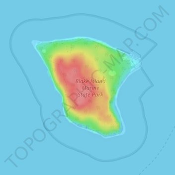
Name: Blake Island topographic map, elevation, terrain.
Location: Blake Island, Kitsap County, Washington, United States (47.52962 -122.50594 47.54533 -122.48060)
Average elevation: 9 m
Minimum elevation: 0 m
Maximum elevation: 81 m
Other topographic maps
Click on a map to view its topography, its elevation and its terrain.
![Bainbridge Island topographic map, elevation, terrain](/pub/maps/relation/6cz4/bp9tf/icon.jpg)
Bainbridge Island
United States > Washington > Kitsap County
Bainbridge Island, Kitsap County, Washington, 98110, United States
Average elevation: 24 m
![Port Orchard topographic map, elevation, terrain](/pub/maps/relation/6ws8/d5hrz4/icon.jpg)
Port Orchard
United States > Washington > Kitsap County
Port Orchard, Kitsap County, Washington, United States
Average elevation: 71 m
![Bremerton topographic map, elevation, terrain](/pub/maps/relation/zp3q/f5lbnh/icon.jpg)
Bremerton
United States > Washington > Kitsap County
Bremerton, Kitsap County, Washington, United States
Average elevation: 68 m
![Hood Canal topographic map, elevation, terrain](/pub/maps/relation/9g4s/gzvqdn/icon.jpg)
Hood Canal
United States > Washington > Kitsap County > Port Gamble
Hood Canal, Port Gamble, Kitsap County, Washington, United States
Average elevation: 287 m
![Tracyton topographic map, elevation, terrain](/pub/maps/relation/fqgp/fq8gt/icon.jpg)
Tracyton
United States > Washington > Kitsap County > Tracyton
Tracyton, Kitsap County, Washington, United States
Average elevation: 48 m
![Manchester topographic map, elevation, terrain](/pub/maps/relation/gttf/91d18/icon.jpg)
Manchester
United States > Washington > Kitsap County
Manchester, Kitsap County, Washington, 98353, United States
Average elevation: 42 m
![Holly topographic map, elevation, terrain](/pub/maps/node/dttf/kwbxbf3/icon.jpg)
Holly
United States > Washington > Kitsap County
Holly, Kitsap County, Washington, United States
Average elevation: 59 m
![Burley topographic map, elevation, terrain](/pub/maps/node/4nrr/mslbv51/icon.jpg)
Burley
United States > Washington > Kitsap County
Burley, Kitsap County, Washington, 98359, United States
Average elevation: 67 m
![Enetai topographic map, elevation, terrain](/pub/maps/node/xh4s/43l77m2/icon.jpg)
Enetai
United States > Washington > Kitsap County
Enetai, Kitsap County, Washington, 98310, United States
Average elevation: 38 m
![Kingston topographic map, elevation, terrain](/pub/maps/node/ms51/tshq7rr/icon.jpg)
Kingston
United States > Washington > Kitsap County
Kingston, Kitsap County, Washington, 98346, United States
Average elevation: 33 m
![East Port Orchard topographic map, elevation, terrain](/pub/maps/relation/s5dn/xv6b3/icon.jpg)
East Port Orchard
United States > Washington > Kitsap County
East Port Orchard, Kitsap County, Washington, 98366, United States
Average elevation: 92 m
![East Bremerton topographic map, elevation, terrain](/pub/maps/node/6hs8/dkx8cz4/icon.jpg)
East Bremerton
United States > Washington > Kitsap County > Bremerton
East Bremerton, Bremerton, Kitsap County, Washington, 98310, United States
Average elevation: 72 m
![Sheridan topographic map, elevation, terrain](/pub/maps/node/9mtf/z21mlnx/icon.jpg)
Sheridan
United States > Washington > Kitsap County > Bremerton
Sheridan, Bremerton, Kitsap County, Washington, 98310, United States
Average elevation: 50 m
![Naval Base Kitsap - Bangor topographic map, elevation, terrain](/pub/maps/relation/gwb3/tdx7rr/icon.jpg)
Naval Base Kitsap - Bangor
United States > Washington > Kitsap County
Naval Base Kitsap - Bangor, Kitsap County, Washington, 98315, United States
Average elevation: 67 m
![Belfair topographic map, elevation, terrain](/pub/maps/node/nwcz/z2vttnx/icon.jpg)
Belfair
United States > Washington > Kitsap County > Bremerton > Belfair
Belfair, Bremerton, Kitsap County, Washington, United States
Average elevation: 103 m
![Hansville topographic map, elevation, terrain](/pub/maps/node/sgm2/t4mg7cz/icon.jpg)
Hansville
United States > Washington > Kitsap County
Hansville, Kitsap County, Washington, 98340, United States
Average elevation: 14 m
![Illahee topographic map, elevation, terrain](/pub/maps/node/81h/kwgpmb3/icon.jpg)
Illahee
United States > Washington > Kitsap County
Illahee, Kitsap County, Washington, 98310, United States
Average elevation: 62 m
![Seabeck Creek topographic map, elevation, terrain](/pub/maps/relation/vltj/z8hp18/icon.jpg)
Seabeck Creek
United States > Washington > Kitsap County
Seabeck Creek, Kitsap County, Washington, 98380, United States
Average elevation: 108 m
![Bremerton topographic map, elevation, terrain](/pub/maps/node/ll18/fw1qcbtp/icon.jpg)
Bremerton
United States > Washington > Kitsap County > Bremerton > Bremerton
Bremerton, Kitsap County, Washington, 98337, United States
Average elevation: 66 m
![Bainbridge Island topographic map, elevation, terrain](/pub/maps/relation/p53q/lg3q9m/icon.jpg)
Bainbridge Island
United States > Washington > Kitsap County > Bainbridge Island
Bainbridge Island, Kitsap County, Washington, 98110, United States
Average elevation: 29 m
![Port Orchard topographic map, elevation, terrain](/pub/maps/node/9w5k/plmnhm2/icon.jpg)
Port Orchard
United States > Washington > Kitsap County
Port Orchard, Kitsap County, Washington, 98366, United States
Average elevation: 61 m
![Striebels Corner topographic map, elevation, terrain](/pub/maps/node/1hm2/xbqc2kl/icon.jpg)
Striebels Corner
United States > Washington > Kitsap County > Striebels Corner
Striebels Corner, Kitsap County, Washington, 89370, United States
Average elevation: 48 m
![Brownsville topographic map, elevation, terrain](/pub/maps/node/5dtf/msdf751/icon.jpg)
Brownsville
United States > Washington > Kitsap County > Brownsville
Brownsville, Kitsap County, Washington, 98345, United States
Average elevation: 32 m
![Poulsbo topographic map, elevation, terrain](/pub/maps/node/v1rr/dgkdds8/icon.jpg)
Poulsbo
United States > Washington > Kitsap County > Poulsbo > Poulsbo
Poulsbo, Kitsap County, Washington, 98061, United States
Average elevation: 76 m
![Eldorado Hills topographic map, elevation, terrain](/pub/maps/node/9l14/3f63ndn/icon.jpg)
Eldorado Hills
United States > Washington > Kitsap County
Eldorado Hills, Kitsap County, Washington, 98383, United States
Average elevation: 78 m
![Jackson Park topographic map, elevation, terrain](/pub/maps/node/4pcz/z2v49nx/icon.jpg)
Jackson Park
United States > Washington > Kitsap County > Jackson Park Support Area > Jackson Park
Jackson Park, Jackson Park Support Area, Kitsap County, Washington, 98312, United States
Average elevation: 39 m
![Port Gamble topographic map, elevation, terrain](/pub/maps/node/mv1h/kwgm1b3/icon.jpg)
Port Gamble
United States > Washington > Kitsap County > Port Gamble
Port Gamble, Kitsap County, Washington, 98364, United States
Average elevation: 31 m
![Olalla topographic map, elevation, terrain](/pub/maps/node/pjrr/kwbjzb3/icon.jpg)
Olalla
United States > Washington > Kitsap County
Olalla, Kitsap County, Washington, 98359, United States
Average elevation: 48 m
![Poulsbo topographic map, elevation, terrain](/pub/maps/relation/wwzs/dzrgp/icon.jpg)
Poulsbo
United States > Washington > Kitsap County
Poulsbo, Kitsap County, Washington, United States
Average elevation: 75 m
![Silverdale topographic map, elevation, terrain](/pub/maps/relation/hkcz/9vds8/icon.jpg)
Silverdale
United States > Washington > Kitsap County
Silverdale, Kitsap County, Washington, 98383, United States
Average elevation: 68 m