
Mariehamns stad topographic map
Interactive map
Click on the map to display elevation.
About this map
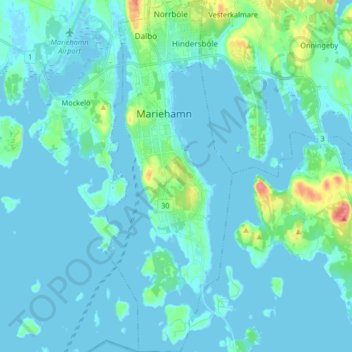
Name: Mariehamns stad topographic map, elevation, terrain.
Location: Mariehamns stad, Åland, Finlande (60.04667 19.91312 60.12899 19.97328)
Average elevation: 7 m
Minimum elevation: -3 m
Maximum elevation: 55 m
Other topographic maps
Click on a map to view its topography, its elevation and its terrain.
Märket
Finlande > Åland > Hammarland
Märket, Hammarland, Ålands landsbygd, Åland, Finlande
Average elevation: 0 m
Hammarland
Finlande > Åland > Hammarland
Hammarland, Ålands landsbygd, Åland, 22240, Finlande
Average elevation: 3 m