
Thank you for supporting this site ❤️
Make a donation
Make a donation
Rancho Cucamonga topographic map
Click on the map to display elevation.
Thank you for supporting this site ❤️
Make a donation
Make a donation
About this map
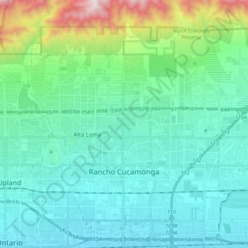
Name: Rancho Cucamonga topographic map, elevation, terrain.
Average elevation: 539 m
Minimum elevation: 290 m
Maximum elevation: 1,658 m
Thank you for supporting this site ❤️
Make a donation
Make a donation
Other topographic maps
Click on a map to view its topography, its elevation and its terrain.
Arrowhead
United States > California > San Bernardino County > San Bernardino > Arrowhead
Average elevation: 383 m