
Thank you for supporting this site ❤️
Make a donation
Make a donation
Predore topographic map
Click on the map to display elevation.
Thank you for supporting this site ❤️
Make a donation
Make a donation
About this map
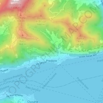
Name: Predore topographic map, elevation, terrain.
Location: Predore, Bergamo, Lombardy, 24060, Italy (45.66862 9.98896 45.70125 10.05575)
Average elevation: 459 m
Minimum elevation: 182 m
Maximum elevation: 1,307 m
Thank you for supporting this site ❤️
Make a donation
Make a donation
Other topographic maps
Click on a map to view its topography, its elevation and its terrain.
Thank you for supporting this site ❤️
Make a donation
Make a donation
Thank you for supporting this site ❤️
Make a donation
Make a donation