
San Salvador topographic map
Interactive map
Click on the map to display elevation.
San Salvador
The city is located in the Boquerón Volcano Valley, a region of high seismic activity. The city's average elevation is 659 meters (2,162 feet) above sea level, but ranges from a highest point of 1,186 meters (3,891 feet) above sea level to a lowest point of 596 m (1,955 ft) above sea level.
About this map
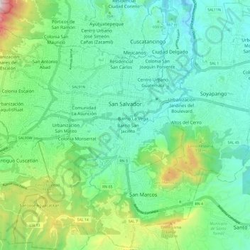
Name: San Salvador topographic map, elevation, terrain.
Location: San Salvador, Departamento de San Salvador, El Salvador (13.63262 -89.27672 13.74592 -89.16288)
Average elevation: 774 m
Minimum elevation: 518 m
Maximum elevation: 1,548 m