
Thank you for supporting this site ❤️
Make a donation
Make a donation
Rhodes topographic map
Click on the map to display elevation.
Thank you for supporting this site ❤️
Make a donation
Make a donation
Rhodes
Rhodes is situated 363 km (226 mi) east-southeast from the Greek mainland, and 18 km (11 mi) from the southern shore of Turkey. Mount Attavyros, at 1,216 metres (3,990 ft), is the island's highest point of elevation.
Thank you for supporting this site ❤️
Make a donation
Make a donation
About this map
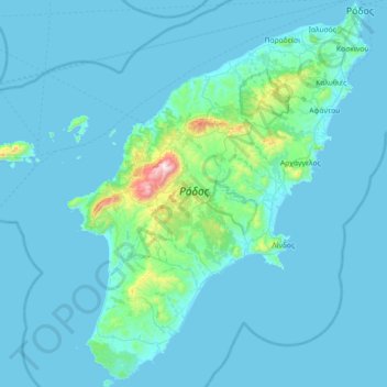
Name: Rhodes topographic map, elevation, terrain.
Location: Rhodes, Aegean, Greece (35.87666 27.68357 36.45828 28.24763)
Average elevation: 67 m
Minimum elevation: 0 m
Maximum elevation: 1,200 m
Thank you for supporting this site ❤️
Make a donation
Make a donation
Other topographic maps
Click on a map to view its topography, its elevation and its terrain.