
Marktgemeinde Telfs topographic map
Interactive map
Click on the map to display elevation.
About this map
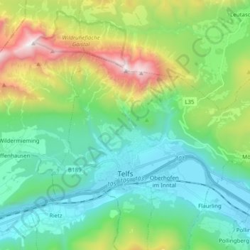
Name: Marktgemeinde Telfs topographic map, elevation, terrain.
Average elevation: 1,162 m
Minimum elevation: 604 m
Maximum elevation: 2,684 m
2011 fuhr Wolfgang Mader auf der Straße Sagl–Mösern einen Ausdauer-Höhenmeterrekord am Rad.
Other topographic maps
Click on a map to view its topography, its elevation and its terrain.
Hinterberg
Österreich > Tirol > Bezirk Innsbruck-Land > Marktgemeinde Telfs > Hinterberg
Hinterberg, Marktgemeinde Telfs, Bezirk Innsbruck-Land, Tirol, 6410, Österreich
Average elevation: 902 m