
Biberist topographic map
Interactive map
Click on the map to display elevation.
Biberist
Biberist liegt auf 447 m ü. M., 3 km südsüdöstlich des Kantonshauptortes Solothurn (Luftlinie). Die Industriegemeinde erstreckt sich an der unteren Emme und am Dorfbach, dem Unterlauf des Biberenbaches, am Nordostrand der Molassehöhen des Bucheggberges und am Rand der Schwemmebene der Emme, im Solothurner Mittelland.
About this map
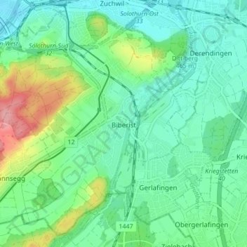
Name: Biberist topographic map, elevation, terrain.
Average elevation: 462 m
Minimum elevation: 428 m
Maximum elevation: 556 m