
Livermore topographic map
Interactive map
Click on the map to display elevation.
About this map
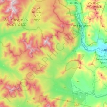
Name: Livermore topographic map, elevation, terrain.
Location: Livermore, Grafton County, New Hampshire, United States (43.97360 -71.62805 44.16881 -71.34686)
Average elevation: 692 m
Minimum elevation: 207 m
Maximum elevation: 1,409 m
The village of Livermore was benchmarked with an elevation of 1,264 feet (385 m), a quarter mile from the eastern boundary adjoining Hart's Location.
Other topographic maps
Click on a map to view its topography, its elevation and its terrain.
Mount Osceola
United States > New Hampshire > Livermore
Mount Osceola, Livermore, Grafton County, New Hampshire, United States
Average elevation: 1,001 m