
Make a donation
Saxton topographic map
Click on the map to display elevation.
Make a donation
About this map
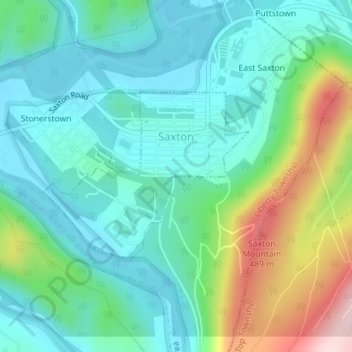
Name: Saxton topographic map, elevation, terrain.
Location: Saxton, Bedford County, Pennsylvania, 16678, United States (40.20593 -78.25777 40.21872 -78.23948)
Average elevation: 317 m
Minimum elevation: 240 m
Maximum elevation: 532 m
Make a donation
Other topographic maps
Click on a map to view its topography, its elevation and its terrain.
Waterside
United States > Pennsylvania > Bedford County > South Woodbury Township
Average elevation: 431 m
New Enterprise
United States > Pennsylvania > Bedford County > South Woodbury Township
Average elevation: 397 m
Blue Knob
United States > Pennsylvania > Bedford County > Pavia Township
Blue Knob (elevation 3,146 feet (959 m)) is a summit in the eastern United States with a broad dome that is the northernmost 3,000-footer in the Allegheny Mountains. It is the highest point in Bedford County, Pennsylvania.
Average elevation: 792 m
Stiefler Corner
United States > Pennsylvania > Bedford County > Kimmel Township
Average elevation: 520 m
Make a donation
Breezewood
United States > Pennsylvania > Bedford County > East Providence Township
Average elevation: 413 m
Texas Corner
United States > Pennsylvania > Bedford County > South Woodbury Township
Average elevation: 462 m
Yellow Creek
United States > Pennsylvania > Bedford County > Hopewell Township > Yellow Creek
Average elevation: 323 m
Make a donation
State Line
United States > Pennsylvania > Bedford County > Londonderry Township
Average elevation: 329 m
Chaneysville
United States > Pennsylvania > Bedford County > Southampton Township
Average elevation: 373 m
Make a donation
Blue Knob
United States > Pennsylvania > Bedford County > Pavia Township
Blue Knob (elevation 3,146 feet (959 m)) is a summit in the eastern United States with a broad dome that is the northernmost 3,000-footer in the Allegheny Mountains. It is the highest point in Bedford County, Pennsylvania.
Average elevation: 792 m