
Costa topographic map
Interactive map
Click on the map to display elevation.
About this map
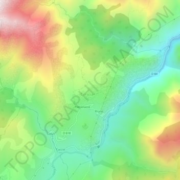
Name: Costa topographic map, elevation, terrain.
Average elevation: 927 m
Minimum elevation: 513 m
Maximum elevation: 1,575 m
Other topographic maps
Click on a map to view its topography, its elevation and its terrain.
Source de Ghiarghe Rosse
France > Corse > Haute-Corse > Corscia
Source de Ghiarghe Rosse, Asco-Corscia trail, U Debbiu, Corscia, Corte, Haute-Corse, Corse, France métropolitaine, 20224, France
Average elevation: 2,123 m