
Thank you for supporting this site ❤️
Make a donation
Make a donation
Berguedà topographic map
Click on the map to display elevation.
Thank you for supporting this site ❤️
Make a donation
Make a donation
About this map
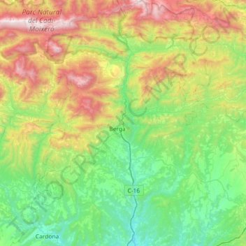
Name: Berguedà topographic map, elevation, terrain.
Location: Berguedà, Barcelona, Catalunha, Espanha (41.89744 1.61035 42.32330 2.07024)
Average elevation: 1,010 m
Minimum elevation: 327 m
Maximum elevation: 2,633 m
Thank you for supporting this site ❤️
Make a donation
Make a donation
Other topographic maps
Click on a map to view its topography, its elevation and its terrain.
Thank you for supporting this site ❤️
Make a donation
Make a donation
Thank you for supporting this site ❤️
Make a donation
Make a donation
Serra de la Coma
Espanha > Catalunha > Alt Urgell > Ribera d'Urgellet > La Freita
Average elevation: 1,011 m