
Sullivan County topographic map
Interactive map
Click on the map to display elevation.
About this map
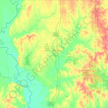
Name: Sullivan County topographic map, elevation, terrain.
Location: Sullivan County, Indiana, États-Unis d'Amérique (38.90373 -87.64599 39.26125 -87.23946)
Average elevation: 155 m
Minimum elevation: 124 m
Maximum elevation: 208 m
Other topographic maps
Click on a map to view its topography, its elevation and its terrain.
Fountain County
États-Unis d'Amérique > Indiana
Fountain County, Indiana, États-Unis d'Amérique
Average elevation: 206 m
Valparaiso
États-Unis d'Amérique > Indiana > Porter County > Valparaiso
Valparaiso, Porter County, Indiana, 46383, États-Unis d'Amérique
Average elevation: 235 m
Fort Wayne
États-Unis d'Amérique > Indiana > Comté d'Allen > Fort Wayne
Fort Wayne, Comté d'Allen, Indiana, 46802, États-Unis d'Amérique
Average elevation: 248 m
Bengal
États-Unis d'Amérique > Indiana > Bengal
Bengal, Shelby County, Indiana, États-Unis d'Amérique
Average elevation: 222 m