
powiat gryficki topographic map
Interactive map
Click on the map to display elevation.
About this map
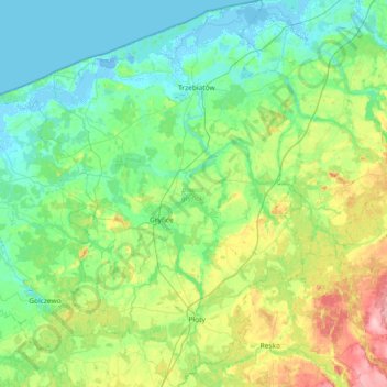
Name: powiat gryficki topographic map, elevation, terrain.
Location: powiat gryficki, Poméranie occidentale, Pologne (53.72681 14.89524 54.15988 15.48625)
Average elevation: 29 m
Minimum elevation: -8 m
Maximum elevation: 126 m
Other topographic maps
Click on a map to view its topography, its elevation and its terrain.
Recz
Pologne > Poméranie occidentale > Recz
Recz, gmina Recz, powiat choszczeński, Poméranie occidentale, 73-210, Pologne
Average elevation: 68 m