
North-Western Province topographic map
Interactive map
Click on the map to display elevation.
North-Western Province
North-Western Province is bordered along Angola in the west, DR Congo in the north, Copperbelt Province in the east, Central in the south-east and Western Province in the south-west. The general topography of the province is characterized by uplifted planation surfaces. The general elevation of the nation as a whole is tended towards West to East from the Kalahari Basin. The level of land falls from the upper Congo towards the Zambezi depression in the South forming a plateau.
About this map
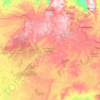
Name: North-Western Province topographic map, elevation, terrain.
Location: North-Western Province, Zambia (-14.73328 22.00039 -10.88783 27.63002)
Average elevation: 1,199 m
Minimum elevation: 872 m
Maximum elevation: 1,737 m
Other topographic maps
Click on a map to view its topography, its elevation and its terrain.