
Crystal topographic map
Interactive map
Click on the map to display elevation.
About this map
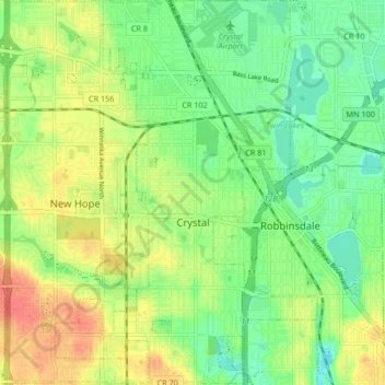
Name: Crystal topographic map, elevation, terrain.
Location: Crystal, Hennepin County, Minnesota, 55429, United States (45.00690 -93.39037 45.06571 -93.33369)
Average elevation: 273 m
Minimum elevation: 251 m
Maximum elevation: 300 m
Other topographic maps
Click on a map to view its topography, its elevation and its terrain.
Long Lake
United States > Minnesota > Hennepin County
Long Lake, Hennepin County, Minnesota, 55356, United States
Average elevation: 300 m
Minneapolis
United States > Minnesota > Hennepin County > Minneapolis
Minneapolis, Hennepin County, Minnesota, 55488, United States
Average elevation: 271 m