
Thank you for supporting this site ❤️
Make a donation
Make a donation
Mungii topographic map
Click on the map to display elevation.
Thank you for supporting this site ❤️
Make a donation
Make a donation
About this map
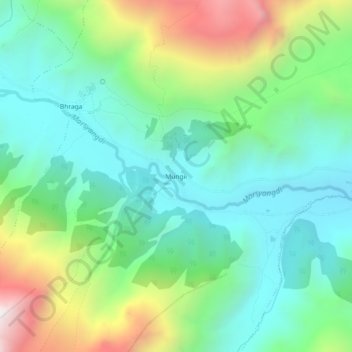
Name: Mungii topographic map, elevation, terrain.
Location: Mungii, Neshyang-05, Neshyang, मनाङ, Gandaki, Népal (28.62922 84.03347 28.66922 84.07347)
Average elevation: 3,767 m
Minimum elevation: 3,389 m
Maximum elevation: 4,647 m
Thank you for supporting this site ❤️
Make a donation
Make a donation
Other topographic maps
Click on a map to view its topography, its elevation and its terrain.