
Thank you for supporting this site ❤️
Make a donation
Make a donation
Freán topographic map
Click on the map to display elevation.
Thank you for supporting this site ❤️
Make a donation
Make a donation
About this map
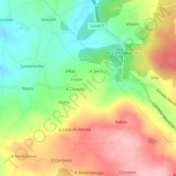
Name: Freán topographic map, elevation, terrain.
Location: Freán, O Saviñao, Terra de Lemos, Lugo, Galicia, Spain (42.58502 -7.68973 42.60222 -7.66897)
Average elevation: 572 m
Minimum elevation: 492 m
Maximum elevation: 661 m
Thank you for supporting this site ❤️
Make a donation
Make a donation
Other topographic maps
Click on a map to view its topography, its elevation and its terrain.