
Thank you for supporting this site ❤️
Make a donation
Make a donation
Ashwater topographic map
Click on the map to display elevation.
Thank you for supporting this site ❤️
Make a donation
Make a donation
About this map
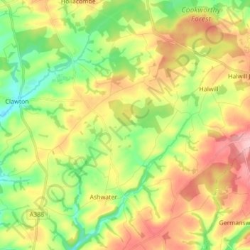
Name: Ashwater topographic map, elevation, terrain.
Location: Ashwater, Torridge District, Devon, England, United Kingdom (50.71670 -4.32699 50.80461 -4.23713)
Average elevation: 155 m
Minimum elevation: 91 m
Maximum elevation: 233 m
Thank you for supporting this site ❤️
Make a donation
Make a donation
Other topographic maps
Click on a map to view its topography, its elevation and its terrain.