
Grand County topographic map
Interactive map
Click on the map to display elevation.
About this map
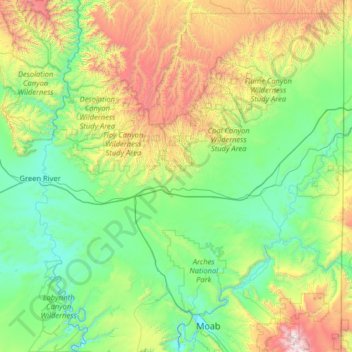
Name: Grand County topographic map, elevation, terrain.
Location: Grand County, Utah, États-Unis d'Amérique (38.49951 -110.17937 39.49969 -109.05068)
Average elevation: 1,747 m
Minimum elevation: 1,201 m
Maximum elevation: 3,693 m
Other topographic maps
Click on a map to view its topography, its elevation and its terrain.
Ophir
États-Unis d'Amérique > Utah > Tooele County
Ophir, Tooele County, Utah, États-Unis d'Amérique
Average elevation: 2,232 m
Bryce Canyon
États-Unis d'Amérique > Utah > Garfield County > Tropic
Bryce Canyon, Tropic, Garfield County, Utah, 84776, États-Unis d'Amérique
Average elevation: 2,247 m
Kester
États-Unis d'Amérique > Utah > Salt Lake County > Sandy
Kester, Sandy, Salt Lake County, Utah, 84070, États-Unis d'Amérique
Average elevation: 1,370 m
Cannonville
États-Unis d'Amérique > Utah > Cannonville
Cannonville, Garfield County, Utah, 84718, États-Unis d'Amérique
Average elevation: 1,843 m
Logan
États-Unis d'Amérique > Utah > Logan
Logan, Cache County, Utah, États-Unis d'Amérique
Average elevation: 1,498 m
Orderville
États-Unis d'Amérique > Utah > Orderville
Orderville, Kane County, Utah, États-Unis d'Amérique
Average elevation: 1,826 m
Roy
États-Unis d'Amérique > Utah > Weber County
Roy, Weber County, Utah, 84067, États-Unis d'Amérique
Average elevation: 1,344 m
Grand Lac Salé
Grand Lac Salé, Box Elder County, Utah, États-Unis d'Amérique
Average elevation: 1,380 m
Salt Lake City
États-Unis d'Amérique > Utah > Salt Lake City
Salt Lake City, Salt Lake County, Utah, États-Unis d'Amérique
Average elevation: 1,592 m
St. George
États-Unis d'Amérique > Utah > St. George
St. George, Washington County, Utah, États-Unis d'Amérique
Average elevation: 929 m
Arches National Park
Arches National Park, Arches Hiking, Grand County, Utah, États-Unis d'Amérique
Average elevation: 1,476 m