
Kragujevac topographic map
Interactive map
Click on the map to display elevation.
About this map
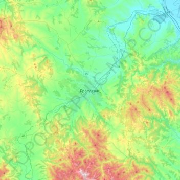
Name: Kragujevac topographic map, elevation, terrain.
Average elevation: 320 m
Minimum elevation: 98 m
Maximum elevation: 888 m
Other topographic maps
Click on a map to view its topography, its elevation and its terrain.
Arandjelovac
Serbia > Central Serbia > Sumadija Administrative District > Arandjelovac Municipality
Arandjelovac, Arandjelovac Municipality, Sumadija Administrative District, Central Serbia, 34300, Serbia
Average elevation: 326 m