
Jiutepec topographic map
Interactive map
Click on the map to display elevation.
About this map
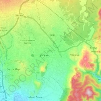
Name: Jiutepec topographic map, elevation, terrain.
Location: Jiutepec, Morelos, México (18.83597 -99.21714 18.93670 -99.11938)
Average elevation: 1,416 m
Minimum elevation: 1,205 m
Maximum elevation: 1,780 m
Other topographic maps
Click on a map to view its topography, its elevation and its terrain.
Volcán Raices
Volcán Raices, Huitzilac, Morelos, 40020, México
Average elevation: 3,030 m
Volcán Los Cardos
Volcán Los Cardos, Huitzilac, Morelos, 40020, México
Average elevation: 3,029 m
Atlacholoaya
México > Morelos > Xochitepec > Atlacholoaya
Atlacholoaya, Xochitepec, Morelos, 62772, México
Average elevation: 1,104 m
Real Santa Fe
México > Morelos > Xochitepec > Atlacholoaya
Real Santa Fe, Atlacholoaya, Xochitepec, Morelos, México
Average elevation: 1,071 m