
VII. kerület topographic map
Interactive map
Click on the map to display elevation.
About this map
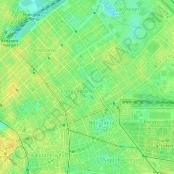
Name: VII. kerület topographic map, elevation, terrain.
Location: VII. kerület, Boedapest, Centraal-Hongarije, Hongarije (47.49431 19.05516 47.51122 19.09114)
Average elevation: 115 m
Minimum elevation: 102 m
Maximum elevation: 125 m
Other topographic maps
Click on a map to view its topography, its elevation and its terrain.
V. kerület
V. kerület, Boedapest, Centraal-Hongarije, Hongarije
Average elevation: 122 m
Lágymányos
Lágymányos, 11. kerület, Boedapest, Közép-Magyarország, Hongarije
Average elevation: 117 m
Újlipótváros
Újlipótváros, 13. kerület, Boedapest, Közép-Magyarország, Hongarije
Average elevation: 110 m