
Marxheim topographic map
Interactive map
Click on the map to display elevation.
About this map
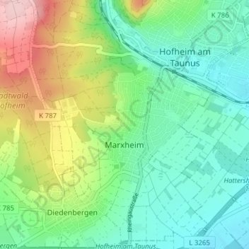
Name: Marxheim topographic map, elevation, terrain.
Average elevation: 179 m
Minimum elevation: 110 m
Maximum elevation: 331 m
Other topographic maps
Click on a map to view its topography, its elevation and its terrain.
Wildsachsen
Deutschland > Hessen > Main-Taunus-Kreis > Hofheim am Taunus
Wildsachsen, Hofheim am Taunus, Main-Taunus-Kreis, Hessen, Deutschland
Average elevation: 290 m
Diedenbergen
Deutschland > Hessen > Main-Taunus-Kreis > Hofheim am Taunus
Diedenbergen, Hofheim am Taunus, Main-Taunus-Kreis, Hessen, Deutschland
Average elevation: 173 m