
Thank you for supporting this site ❤️
Make a donation
Make a donation
Eugene topographic map
Click on the map to display elevation.
Thank you for supporting this site ❤️
Make a donation
Make a donation
About this map
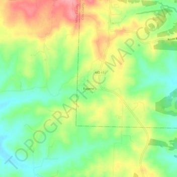
Name: Eugene topographic map, elevation, terrain.
Location: Eugene, Cole County, Missouri, 65032, United States (38.33281 -92.42379 38.37281 -92.38379)
Average elevation: 252 m
Minimum elevation: 207 m
Maximum elevation: 307 m
Thank you for supporting this site ❤️
Make a donation
Make a donation
Other topographic maps
Click on a map to view its topography, its elevation and its terrain.