
Marshall topographic map
Interactive map
Click on the map to display elevation.
About this map
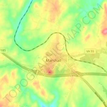
Name: Marshall topographic map, elevation, terrain.
Average elevation: 189 m
Minimum elevation: 144 m
Maximum elevation: 238 m
Other topographic maps
Click on a map to view its topography, its elevation and its terrain.
Pilgrims Rest
Vereinigte Staaten von Amerika > Virginia > Fauquier County
Pilgrims Rest, Fauquier County, Virginia, 20137, Vereinigte Staaten von Amerika
Average elevation: 160 m
The Plains
Vereinigte Staaten von Amerika > Virginia > Fauquier County
The Plains, Fauquier County, Virginia, Vereinigte Staaten von Amerika
Average elevation: 180 m