
North Seekonk topographic map
Interactive map
Click on the map to display elevation.
About this map
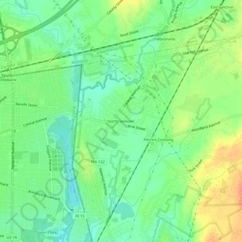
Name: North Seekonk topographic map, elevation, terrain.
Average elevation: 26 m
Minimum elevation: 8 m
Maximum elevation: 51 m
Other topographic maps
Click on a map to view its topography, its elevation and its terrain.
Monroes
United States > Massachusetts > Bristol County > Seekonk
Monroes, Seekonk, Bristol County, Massachusetts, 02806, United States
Average elevation: 4 m
Harris
United States > Massachusetts > Bristol County > Seekonk
Harris, Seekonk, Bristol County, Massachusetts, 02771, United States
Average elevation: 14 m
Perrins Crossing
United States > Massachusetts > Bristol County > Seekonk
Perrins Crossing, Seekonk, Bristol County, Massachusetts, 02861, United States
Average elevation: 29 m