
Thank you for supporting this site ❤️
Make a donation
Make a donation
Biene topographic map
Click on the map to display elevation.
Thank you for supporting this site ❤️
Make a donation
Make a donation
About this map
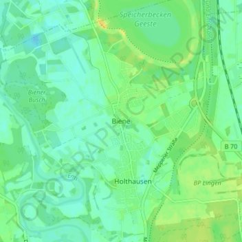
Name: Biene topographic map, elevation, terrain.
Average elevation: 22 m
Minimum elevation: 14 m
Maximum elevation: 36 m
Thank you for supporting this site ❤️
Make a donation
Make a donation
Other topographic maps
Click on a map to view its topography, its elevation and its terrain.
49811
Deutschland > Niedersachsen > Landkreis Emsland > Lingen (Ems) > Baccum > Övernhoff
Average elevation: 33 m
Thank you for supporting this site ❤️
Make a donation
Make a donation