
Thank you for supporting this site ❤️
Make a donation
Make a donation
Rochester topographic map
Click on the map to display elevation.
Thank you for supporting this site ❤️
Make a donation
Make a donation
About this map
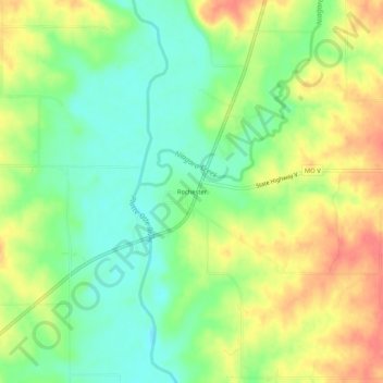
Name: Rochester topographic map, elevation, terrain.
Location: Rochester, Andrew County, Missouri, 64459, United States (39.89222 -94.70468 39.93222 -94.66468)
Average elevation: 288 m
Minimum elevation: 260 m
Maximum elevation: 322 m
Thank you for supporting this site ❤️
Make a donation
Make a donation
Other topographic maps
Click on a map to view its topography, its elevation and its terrain.
Thank you for supporting this site ❤️
Make a donation
Make a donation
Thank you for supporting this site ❤️
Make a donation
Make a donation