
Thank you for supporting this site ❤️
Make a donation
Make a donation
Amery topographic map
Click on the map to display elevation.
Thank you for supporting this site ❤️
Make a donation
Make a donation
About this map
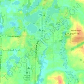
Name: Amery topographic map, elevation, terrain.
Location: Amery, Polk County, Wisconsin, United States (45.27395 -92.38261 45.32530 -92.34016)
Average elevation: 330 m
Minimum elevation: 316 m
Maximum elevation: 358 m
Thank you for supporting this site ❤️
Make a donation
Make a donation
Other topographic maps
Click on a map to view its topography, its elevation and its terrain.