
Réservoir Choinière topographic map
Interactive map
Click on the map to display elevation.
About this map
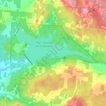
Name: Réservoir Choinière topographic map, elevation, terrain.
Average elevation: 182 m
Minimum elevation: 120 m
Maximum elevation: 267 m
Other topographic maps
Click on a map to view its topography, its elevation and its terrain.
Parc national de la Yamaska
Canada > Québec > La Haute-Yamaska > Saint-Joachim-de-Shefford
Parc national de la Yamaska, Saint-Joachim-de-Shefford, La Haute-Yamaska, Estrie, Québec, Canada
Average elevation: 173 m