
Make a donation
Palisade Glacier topographic map
Click on the map to display elevation.
Make a donation
About this map
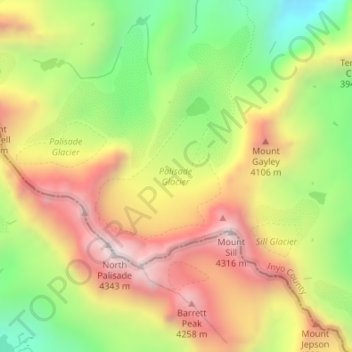
Name: Palisade Glacier topographic map, elevation, terrain.
Location: Palisade Glacier, Inyo County, California, United States (37.09543 -118.51627 37.10508 -118.50418)
Average elevation: 3,839 m
Minimum elevation: 3,364 m
Maximum elevation: 4,310 m
Make a donation
Other topographic maps
Click on a map to view its topography, its elevation and its terrain.
Make a donation
Darwin
United States > California > Inyo County
Darwin is an unincorporated mining community in Inyo County, California, United States. It is located 22 miles (35 km) southeast of Keeler, at an elevation of 4,790 ft (1,460 m). The population was 43 at the 2010 census, down from 54 at the 2000 census.
Average elevation: 1,484 m
Make a donation
Cartago
United States > California > Inyo County
Cartago (Spanish for "Carthage") is a census-designated place in Inyo County, California, United States. Cartago is located on the west side of Owens Lake 3 miles (4.8 km) north-northwest of Olancha, at an elevation of 3629 feet (1106 m). The population was 92 at the 2010 census, down from 109 at the 2000…
Average elevation: 1,152 m
Big Pine
United States > California > Inyo County
Big Pine (formerly Bigpine) is a census-designated place (CDP) in Inyo County, California, United States. Big Pine is located approximately 15 miles (24 km) south-southeast of Bishop, at an elevation of 3,989 feet (1,216 m). The population was 1,756 at the 2010 census, up from 1,350 at the 2000 census. The Big…
Average elevation: 1,232 m
Charleston View
United States > California > Inyo County
Charleston View, formally known as Calvada Springs, is an unincorporated community in Inyo County, California. It lies at an elevation of 2621 feet (799 m). The Charleston View CDP had a population of 45 in the 2020 census
Average elevation: 802 m
Make a donation
Make a donation
Make a donation
Independence
United States > California > Inyo County
Independence is a census-designated place in Inyo County, California. Independence is located 41 miles (66 km) south-southeast of Bishop, at an elevation of 3930 feet (1198 m). It is the county seat of Inyo County, California. The population of this census-designated place was 669 at the 2010 census, up from…
Average elevation: 1,210 m
Make a donation
Make a donation
Make a donation
Make a donation
Olancha
United States > California > Inyo County
Olancha (Timbisha: Pakwa' si) is a census designated place in Inyo County of the U.S. state of California. Olancha is located on U.S. Route 395 in California, 37 miles (60 km) south-southeast of Independence, at an elevation of 3658 feet (1115 m). As of the 2010 census, the population was 192, up from 134 at…
Average elevation: 1,200 m
Make a donation
Alabama Hills
United States > California > Inyo County
Alabama Hills is an unincorporated community in the Alabama Hills, in Inyo County, California.[1] It lies at an elevation of 4534 feet (1382 m).[1] The community was named after the CSS Alabama.[2]
Average elevation: 1,427 m
Make a donation