
Rupandehi topographic map
Interactive map
Click on the map to display elevation.
About this map
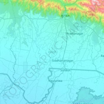
Name: Rupandehi topographic map, elevation, terrain.
Location: Rupandehi, Lumbini Province, Nepal (27.33016 83.20425 27.76729 83.63440)
Average elevation: 182 m
Minimum elevation: 86 m
Maximum elevation: 1,800 m
The district lies on the southern and western part of Nepal. On the East it shares border with Nawalparasi District, on West with Kapilvastu District, on North with Palpa District and on South with India. The elevation of the district lies between 100m to 1229m from sea level. The total area of the district is 1,360 km2 with 16.1% in Churia Range and rest in the Terai region.
Other topographic maps
Click on a map to view its topography, its elevation and its terrain.